Need help?
Call us at (888) 726-4343
Mon-Sat, 9am-5pm, MST

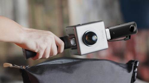
FJ Dynamics Trion P1 3D Handheld LiDAR Scanner is a SLAM-enabled, lightweight handheld laser scanner designed for effortless reality capture. Capture environments seamlessly while walking, and generate detailed 3D models, floor plans, and BIM data. Its internal grip battery ensures an even weight distribution, enhancing both usability and ergonomics for a more comfortable scanning experience.
(Please note that the fisheye camera is sold separately now.)


Wherever you go, the P1 3D floor plan scanner can capture what you see. Map the environment with intricate details inside and outside, from ornate architecture to hidden infrastructure, from forensic evidence to urban vegetation analysis. Powerful SLAM technology enables the P1 to work in direct sunlight or even at night.
Pick up the FJD Trion P1 whenever you want to take a closer look at your world. Weighing in at only 1.15 kg or slightly over 2 lbs, the P1 SLAM LiDAR scanner fits in a messenger bag and can work all day with easy battery swaps, recreating your environment in minutes with 3D LiDAR scanning.


FJD Trion P1 Portable 3D Laser Scanner, paired with up to 2cm of relative accuracy, provides 3D LiDAR scanning results that are more precise, intricate, and lifelike than ever before. Moreover, it can also capture 3D data from a distance of up to 40 meters at a reflectivity level of 10%, which is ideal for multiple using scenarios.
Advanced SLAM technology of FJD Trion P1 does not have to cost a fortune. Say goodbye to complex instrument calibrations and time-consuming data processing workflows. The FJD Trion P1 affordable LiDAR scanner allows you to unleash your creativity, optimize data processing, and digitalize assets with ease.

| Item | Trion P1 |
|---|---|
| Weight | 1.05 kg |
| Scanning Range |
40m@10% reflectivity |
| Scanning Point Frequency | 200,000 points/second |
| Dimensions | 160 × 120 × 270 mm (excluding camera) |
| Camera Resolution | 5760 × 2880 @ 30 fps |
| Camera Field of View (FOV) | 180° |
| Processing/Display | Real-time |
| Protection Class | IP54 |
| Number of Laser Heads | 1 |
| Laser Class | Eye-safety Class I |
| Relative Accuracy | Up to 2cm |
| Storage Capacity | 512 GB |
| Operating Temperature | -10℃ ~ 45℃ |
| Battery Life | 2H (grip battery, room temperature) |
Expand the reach of your FJD Trion laser scanners.
Mount your laser scanner onto the extension pole to map spaces that are hard to access, like manholes and ceiling voids, or stockpiles and hazardous infrastructure.
|
Adjustable Length |
135 cm to 300 cm |
|
Folded Length |
135 cm |
|
Rod section size and wall thickness |
25.2×0.8 mm 28.7×0.8 mm 32.2×0.8 mm |
|
Weight |
760g |
|
Material |
Aluminium alloy |
|
Foam Handle Length |
60 cm |
Q1: What is the scanning range & accuracy of P1 SLAM LiDAR Scanner?
A1: Up to 2mm relative accuracy at a scanning distance of 1m to 40m. Data may be compromised with farther scans, and it is recommended that the scanner is at least 1m away from any object during a scan. It is 40m @10% reflectivity, 70m @80% reflectivity.
Q2: What software should be used to process the data collected by FJD Trion P1?
A2: The FJD Trion P1 generates universal point cloud formats like .las, .pcd, .pts, and .ply, and the data can be directly viewed and processed in by FJD Trion Model point cloud processing software. The .fjdslam format is used for post-processing through FJD Trion Model.
Q3: What scenarios is P1 Portable 3D Laser Scanner designed for? Does it work underground?
A3: The P1 with an affordable LiDAR scanner price works well in feature-rich environments like most LiDAR scanners. For example, floor plans or 3D models for real estate/property assessment, disaster preparedness & recovery, forensic documentation, AEC, game design, urban planning/urban forestry and vegetation management, and robotics deployment. The P1 affordable LiDAR Scanner is designed for applications where speed and efficiency outweigh the level of accuracy required. In spaces where is no reference at all and the features repeat, the P1 may not work as well due to the nature of LiDAR sensors.
Q4: Does P1 Portable 3D Laser Scanner support real-time processing? Can point clouds be processed in real time without a data logger?
A4: Yes, scans can be viewed in real-time in FJD Trion Scan. The P1 stores and processes the data without the need of an external data logger.
Q5: How long does it take to download and process data captured by the P1?
A5: The P1 SLAM LiDAR Scanner takes about one third (1/3) of the scanning time to extract and process point cloud data. For example, a 15-minute scan will take about 5 minutes to process.
Discover the effortless and excellent 3D LiDAR scanning experience with FJD Trion P1 Scanner.
P1 3D floor plan scanner helps you make more informed decisions on your projects from blueprint to QA/QC with building surveys, scan to CAD&BIM, as-built documentation, floor plans, and stockpile volumes.
Manage and monitor tree inventory with a quick walk in the forest with our handheld laser scanner. Measure crowns, analyze breast diameter and tree height using precise point cloud data.
Leverage point cloud data to enhance disaster preparedness and recovery plans with FJD Trion P1 Handheld Laser Scanner. Quickly record evidence and crime or accident scenes for immediate and accurate forensic documentation.
3D room scanner enables the accurate assessment of structural integrity, effective planning of spaces, and identification of areas that require repair or renovation. This reduces uncertainty in investment decisions by providing insights via a rich spatial dataset.
Facilitate communications between teams before and during robotics deployment. Plan routes and enhance robot obstacle avoidance with 2D maps and 3D models of the environment.